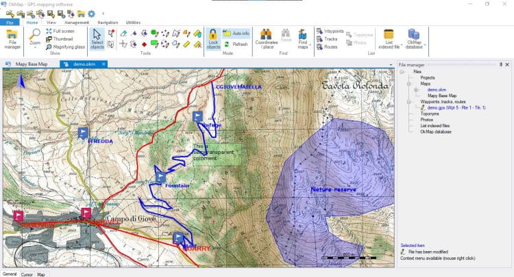
Download OkMap Desktop 18 free – Mapping and GPS software for Windows. It allows you to view digital maps, create paths and navigate outdoors.
OkMap Desktop Overview
OkMap Desktop is a powerful and versatile mapping software that offers a wide range of features for outdoor enthusiasts, hikers, and geocachers. It allows users to create detailed maps from various sources, such as digital elevation models, raster images, and vector maps. The software also supports GPS devices, allowing users to track their movements in real-time and create routes for outdoor activities.
One of the standout features of OkMap Desktop is its ability to overlap different maps and data layers, making it easy to create custom maps with various information. Users can add markers, labels, and symbols to maps, increasing their usefulness for navigation purposes. In addition, the software offers advanced tools for measuring distance, area, and elevation, making it a valuable tool for planning and analyzing outdoor activities.
OkMap Desktop allows users to import and export data in various formats, ensuring compatibility with other mapping software and devices. This includes the ability to import and edit tracks, waypoints, and routes from GPS devices, as well as export maps for offline use on mobile devices. It provides an intuitive and user-friendly interface, making it accessible even to those without much technical knowledge. With a wide range of features and compatibility with various devices, OkMap Desktop becomes an essential tool for anyone who loves the outdoors and wants to create and navigate their own maps.
OkMap Desktop Features
- Display web maps for over 40 servers
- Ability to add new custom web map servers
- Edit/display raster maps (30+ image formats)
- Display vector maps
- Display hybrid maps (raster + vector data)
- Ability to open multiple maps simultaneously
- 10 most used map views
- Coordinate representation in: degrees, degrees-minutes, degrees-minutes-seconds, UTM, ECEF, Georef, US National Grid, British Grid (Survey National Grid), Irish Grid, metric coordinates with custom projection operations
- Database with over 3200 predefined predictions by geographic region
- Database with more than 750 landmarks
- Manage map widgets (icons, comments)
- Manage vector data (points, multipoints, lines, polygons)
- Manage GPX data (waypoints, routes, routes)
- File manager
- Select multiple objects with the mouse
Technical Details and System Requirements
- Supported OS: Windows 11, Windows 10, Windows 8.1, Windows 7
- RAM (Memory): 2 GB RAM (4 GB recommended)
- Free Hard Disk Space: 2 GB or more
Discover more from All Programs
Subscribe to get the latest posts sent to your email.


